Showing posts with label lighthouses. Show all posts

Saturday, January 24, 2015

New Year road trip day 4: Eden and Cooma

Luke was up earlier than I the next morning and took his camera for a stroll around Mallacoota. He returned with a seal story - this one about a big, grumpy seal sunning itself on a jetty which barked at him when he got too close.

We went past again after breakfast and it was still there, snoozing in the sun. The jetty was fairly narrow and the seal was completely blocking the entrance to it. 


A guy berthed his boat at the jetty while Luke was there in the early morning and as he started running up the jetty Luke alerted him to the presence of the seal. He responded with something like, "Oh, not that bloody seal again", so obviously it's a regular hang out for the seal. It's near a fish cleaning station, so perhaps it was waiting for fish snacks.

Speaking of fish, every time I think of this seal or see photos of it, I will remember the bloody awful stench that filled the air near the jetty. I don't have a particularly delicate stomach when it comes to bad smells, but this nearly made me lose my breakfast. It was putrid. Upon investigation, I discovered a fisherman had thrown a small shark's head down onto the water's edge and I don't think it was recently. Not sure why the seal or some other scavenger hadn't eaten it while it was fresh.  


  Zzzzzz

My original itinerary had us travelling from Mallacoota inland to Jindabyne, but we ended up continuing up the coast to Eden in New South Wales. 


 Boats in the delightfully named Snug Cove 

  The garden of Eden is really a 'mongrel landscape' 

After a quick information-gathering stop at the local tourist info centre, we backtracked to visit an old whaling station and the Green Cape Lighthouse, which meant more driving on bumpy, rutted gravel roads. (Finally getting back onto smooth bitumen after bumping along for kilometres on gravel roads is one of life's less common simple pleasures.)  

 The old house at the Davidson Whaling Station, 
which dates back to 1896

The house and other buildings are run as a small museum. On the day we visited a descendant of the Davidsons was there to hand over an old gun to go on display. Our guide pointed out his mother sitting on her mother's knee in a photo on the wall of the house.


Kiah Inlet: calm and serene today, but once where the Davidson
 family brought ashore the whales they hunted for oil

There was an old photo in the house of a man embedded in the blubber of a dead whale. Whale blubber was thought to be good for rheumatism, but anyone undergoing the treatment had to have someone keep an eye on them so they didn't pass out from the heat and stench, and suffocate in the blubber. Thank god for modern medicine.  

Another surprising thing we learned: the whalers took advantage of killer whales' status as the only predator of southern right whale to help them catch their quarry. Packs of killer whales drove the southern rights into shore where they attacked them, making it easier for the whaleboats to capture them. The whalers let the orcas feast on the whales' lips and tongues, and they took the rest of the carcass. Bizarre.  

The Davidson whaling station was set up in 1866 and closed its operations in 1929. It was the longest continuously operating whaling station in Australia.   

Yacht parking to the right please
  
 Next we headed to the Green Cape lighthouse. 


 Disaster Bay on the way 

 Luke's car after another, mercifully short, stretch of dirt road


 Said lighthouse


We had lunch back in Eden, then continued up the coast almost to Merimbula, but then we turned off the highway and took a road less travelled on the way to Cooma (which sadly meant we bypassed the amusingly named town of Numbugga). We were back in gorgeous lush, hilly farmland which had us 'oohing' and 'aahing'.  


 Impending storm


Curious calves


When we stopped in the driveway of a farm to take photos the calves in the paddock on the opposite side of the road mooed at us until I paid them some attention. Once I took their photo, they lost interest. 


A guy came out of the farm on a quadbike and stopped to ask if we were OK. I guess being off the highway they don't see a lot of tourists. When we told him our destination and confessed we weren't certain when were on the right road, he said we were and told us about a lookout up in the nearby mountains, which was on our way.  Unfortunately by the time we reached it (the Bemboka Escarpment), it had started to rain and we couldn't see much. As we got further along the high, winding mountain pass the clouds in the photo above let loose a proper downpour. 

On the other side of the mountains, we arrived at Cooma, which is only just over 100km south of Canberra and notable for its history as headquarters during construction of the Snowy Hydro Scheme (a hydroelectricity and irrigation complex) between 1949 and 1974. 

After finding a room (and breaking an arm off my glasses which I had to mend with a Band-aid), we set off on a walk around town. 


A highland goaty-oaty-oat?

We saw quite a few goats on our travels, but our favourite was a black goat with huge horns we saw near Agnes Falls and dubbed Devil Goat.

Dinner was at the art deco era Alpine Hotel (scotch fillet again), then it was bedtime.  

New Year road trip day 3: Mallacoota

On the third day of our road trip we had a quick look around Lakes Entrance before setting off for Mallacoota at the pointy end of Victoria.


 A yacht just after entering the eponymous entrance


 Synchronised preening near the North Arm Bridge


Nigel No Neck tries to act natural

Our first stop was Marlo, a small coastal town where the Snowy River flows into the Tasman Sea. We saw seals! There were a few people fishing from the jetty and the local seals obviously knew they could expect some fishy tidbits to be thrown their way.  There were two of them and they were very playful. Only one got a fish while we were there because the fisherman only caught one. 


 The mouth of the Snowy River


The man with a baby for a head

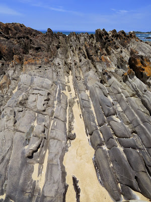
We continued along the coast, stopping at Cape Conran and Cowrie Bay. We took a short walk along a trail through banksia scrub to the rocky beach. 


 Old banskia, new banksia

 Slabs of rock with sharp vertical corrugations


 Smooth blue-grey rocks as big as cantaloupes


Beach art (not of our making)

I picked up some small smooth stones from the beach - there's something very pleasing about holding a smooth stone in the palm of your hand - and we hit the highway again, where rolling hills and farmland had given way to native forest on either side. Next up was Cann River for lunch.

 Charming little church in Cann River

We attempted a walk beside the river after lunch, but unlike most signposted walks, the narrow trail was just a narrow path of flattened grass through the bush. We're all for getting off the beaten track, but not if there's a strong risk of a surprise encounter with a snake (especially as we had bare skin at snake height). It was hot and super humid anyway, so I didn't mind getting back into the air conditioned car. 

While zipping along the highway again we spotted a turn off for Genoa Point in the Croajingolong National Park and hung a rightie onto the gravel road.  Like a lot of places we visited on this trip, this was a spontaneous side-trip. I did do some research before we left, which is where I read about Agnes Falls at Toora, but other stuff we saw signposted along the way and decided to visit on the spur of the moment. We also stopped off at information centres to investigate local walks and attractions. Planning ahead is good, but I think the essence of a road trip is to make it up as you go along.

Anyway, this gravel road was rough, rutted and winding and consequently it felt very long. We finally got to the car park for the walk to Genoa Point to find that it would take a few hours to get to the peak and back, which was more time than we wanted to invest in it. 

So it was back onto the rough gravel road again. We did see a goanna, so it was a worthwhile tangent. 

Tree hugger. It was about a metre long


Ready for his close up

We arrived in Mallacoota around 5 o'clock and booked a motel room. Apart from our first night in Foster, we didn't book any of our accommodation in advance. I think a lot of people must have gone back to work on 5 January so we didn't struggle to find a place to stay anywhere. 

We put our bathers on and headed for the beach - First Bastion Point for a view of Gabo Island. This is the island I mentioned previously that is often mentioned on the ABC weather report (which is because it's a shipping reference). In the end we didn't visit it, but we did see it and its pink granite lighthouse in the distance. 

 Teeny weeny lighthouse at far right 


Closer (hazy) view

It doesn't look it from a distance, but the Gabo Island lighthouse is the second-tallest lighthouse in Australia. 

A beautifully refreshing sea breeze was blowing as we walked along the beach to where the sea and the lake system meet, so we didn't end up going for a swim. I did get my feet wet though and picked up some shells. 

There was an information board at a deck overlooking the beach with information on local flora and fauna, including the Gloomy Octopus. The Gloomy Octopus!!! I thought this was hilarious. How do they know it's not a happy octopus? Can you pick it? 

Yeah, I know, it's hard enough to see the thing, 
let alone determine its emotional state

Then we headed to Betka Beach, on the recommendation of our motel caretaker. During a stroll along the beach I found this blue creature. 


At first I thought it was dead, but as my poking finger got closer to it, it started to wave that tentacle around. Consequently I kept my finger to myself. I guessed it was a blue bottle jellyfish, which I knew to be a nasty customer. When I got home I  googled it and discovered a blue bottle is the same thing as a man o' war jellyfish (which isn't actually a jellyfish). Definitely a nasty customer - its stings are extremely painful and, in rare cases of allergic reaction, can cause deadly side effects. They can still sting for hours or days after death so if you see one on the beach that looks dead, no poking! 

Betka Beach also had a lot of rugged rocks, this time with beautiful ochre seams running through them. We were there during the golden hour, which made them even more attractive. 


Looks like the beach artist was here too


Another local 


Betka Beach - mouth of Betka River in the foreground

From Betka Beach we set out on a coastal walk, much of which took us through tunnels of ti tree that were otherwise deserted and quiet. It was a little spooky. 


Dinner-plate-sized spider webs, 
for added spookiness

By now it was dinner time so we headed back into town and ate in the motel restaurant (more scotch fillet and chips for me). Luke had a swim in the motel pool, but I was too tired. Another early night ensued. 

Sunday, January 26, 2014

Road trip: Day 1 - Melbourne to Warrnambool

I've taken my time getting around to writing about our road trip in early January. It's a long weekend for Australia Day, so I thought I should get off my butt (or, rather, on my butt) and blog. 

On our first day Luke and I drove along the Great Ocean Road (GOR) to Warrnambool. 


Iconic Bells Beach near Torquay. Not a great day for the beach 
(for us, I mean, not surfers) - it was very windy and a bit chilly

The Split Point Lighthouse at Aireys Inlet

It's a pretty little lighthouse

Although the sky was mostly grey, there were some sunny
 breaks which turned the shallows a beautiful aqua blue 

The lush rural hinterland near Apollo Bay...a dramatic
contrast to what was to come later in our trip

That's the ocean at Apollo Bay in the distance

Our next stop was at Cape Otway. There's a lighthouse there, but we thought the admission fee was a bit steep, so we walked to the little historic cemetery nearby instead.  In the late 1800s it was the burial place for about a dozen people mostly connected with the lighthouse (including several infants) and victims of drownings at sea. 

One of the graves is for a seaman who died in the Eric The Red shipwreck in 1880. The ship had sailed from New York en route to Melbourne carrying exhibits for the International Exhibition.

Another is for Thomas Monk who died in the Blanket Bay disaster


It reads: In memory of Albert Griffiths Chief Officer aged 33 years * Thomas Monks aged 34 years * Alexander Mathieson aged 23 years * Who lost their lives in the Blanket Bay disaster 21st March  1896 * Erected on the grave of Thomas Monk by their shipmates and friends

There were tracts of skeletal trees on the road between the GOR and Cape Otway. They were eerily beautiful and reminded me of the trees we saw on top of Lake Mountain in 2012. I don't think they were dead as some were sprouting leaves. I'm not sure what was going on with them. 


Some - the ones with more leaves - had koalas in them! 

 This was the first of several wildlife encounters on our trip

Mmmmm... gum leaves...munch munch munch

We stopped at the little town of Lavers Hill for sustenance and I was thrilled to find a packet of homestyle gluten-free melting moments biscuits. They were delicious too - far superior to ones I bought recently from the gourmet mecca of the David Jones food hall. 

Next up was Melba Gully, a patch of mossy, ferny, licheny, fungusy rainforest with some superb trees. 
 This one has a face, a spooky face

 Moss-covered tree

 Above tree, with tree fern

Fungus on a fallen log

Next up was the best-known stretch of the GOR - the bit with the Twelve Apostles and the other rock formations beyond.

 The Twelve Apostles

 The Apostles again

 The Loch Ard Gorge. The open wild Southern Ocean lies 
through that gap in the rocks 

The Loch Ard Gorge is my favourite. It's a secluded cove bound by high cliffs, with a little beach and a cave at the back with stalactites and stalacmites (below).  I like it because it doesn't attract anywhere near as many tourists as the Twelve Apostles and because when I was in grade six I won an essay competition in which I had to imagine I was one of the two survivors of the Loch Ard shipwreck. My story was published in the local paper. I always think about that when I visit. 

The gorge is named after the ship because the survivors came ashore there. The rugged coast in this part of Victoria is known as the Shipwreck Coast because of the more than 600 sailing ships that came to grief there in the 1800s to early 1900s. 

The cave

 Further alone, the Bay of Martyrs in the golden hour

The sun setting over the Bay of Martyrs 

We continued on to Warrnambool, checked into our motel, managed to get a restaurant meal at 9.30 on a Monday night (Warrnambool is quite large, but still a country town). The restaurant also offered gluten-free options. I was impressed...even though I then chose to eat gluten because bread is delicious.  It's nice to have the option, y'know?

We both slept very well.